
Contents
|
Section X click on thumbnail to see larger photo. Back |
|||||||||||||||||||||||||||||||||||||||||||||||||||||||||||||||||||||
|
A steady climb of >600 m that leads back to Tabletop Trail, a 4WD road. |
|||||||||||||||||||||||||||||||||||||||||||||||||||||||||||||||||||||
 |
 |
 |
|||||||||||||||||||||||||||||||||||||||||||||||||||||||||||||||||||
|
It is a comfortable camp at Blue Mountain/Hole Creek junction, great Bush TV reception. |
Always make sure you put the fire out. No problem this morning – mist and rain. |
Ready to leave. The blue tarp is a combined groundsheet and raincape, ready to cover the pack if it starts raining again. |
|||||||||||||||||||||||||||||||||||||||||||||||||||||||||||||||||||
 |
 |
942.948%20.JPG) |
|||||||||||||||||||||||||||||||||||||||||||||||||||||||||||||||||||
|
Rock Wallabies (Petrogale pencillata) are occasionally seen along Hole Creek They resemble 50 cm brown beanbags until the effortlessly glide up seemingly impossible rock faces. The long tail and roughened feet are keys to their agility. |
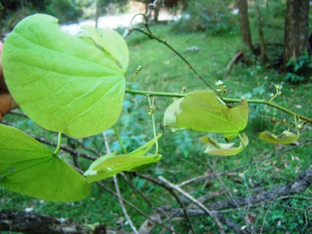
Round-leaf Vine (Legnephora moorei) is a climber with alternate leaves 8-20 cm in diameter , usually with 5 long veins spreading from the base, and a stalk 5-15 cm long. The fruit is a round 8-10 mm blueish-black drupe. Usually found in warmer coastal rainforest. |
We have climbed up from about 330 m at Blue Mountain Creek to 400 m here, and the rain has momentarily stopped. As soon as you feel even slightly warm, get the jumpers off. You can climb in below-zero temperatures in a T-shirt, you may need gloves. |
|||||||||||||||||||||||||||||||||||||||||||||||||||||||||||||||||||
 |
94350.94100%20.JPG) |
946.934%20.JPG) |
|||||||||||||||||||||||||||||||||||||||||||||||||||||||||||||||||||
|
Looking almost due W from waypoint ZINHOLSP2 (AG66 944.943), at an altitude of 600 m. The spur between Blue Mountain and Hole Creek we are looking over, leads up to ‘Cheyenne’. (see Section Y Photoguide for details). |
The big part of the climb is over by here, at 830 m, near Waypoint ZINHOLSP3. It has taken about 2 hours. |
||||||||||||||||||||||||||||||||||||||||||||||||||||||||||||||||||||
948.932%20.JPG) |
|
 |
|||||||||||||||||||||||||||||||||||||||||||||||||||||||||||||||||||
|
At ZINHOLSP4 (AG66 0394850.6593250) What had appeared to be a very narrow ridge on the map is actually quite broad and inviting. The way is clear and obvious to ZINHOLSP5, but needs careful navigation through thicker understorey between stream heads, to hit Waypoint ZINHOLSP7. |
On Tabletop Trail, the 4WD road that winds up around the east side of Tabletop Mountain and on to Tabletop Cross Roads (TTOPXROADS waypoint). | ||||||||||||||||||||||||||||||||||||||||||||||||||||||||||||||||||||
