Contents
|
Section K click on thumbnail to see larger photo. Back |
||||||||||||||||||||||||||||||||||
An easy walk down Tabletop Trail after filling up the water bottles at Salt Hut Dam. The road curls around a bit while crossing a tributary of Hole Creek, but generally it runs easily down, with a few interesting plants on the way. |
||||||||||||||||||||||||||||||||||
|
|
 |
|||||||||||||||||||||||||||||||||
|
The Salt Hut dam, usually very reliable. As with all unprotected water sources, you need to treat water before drinking. |
The smoothbarked tree to the right of the trail is Hillgrove Spotted Gum Eucalyptus michaeliana at about AMG 955/910. They are a very localised species, usually found on steep upper slopes. |
|||||||||||||||||||||||||||||||||
|
|
 |
|||||||||||||||||||||||||||||||||
|
Swinging along very comfortably, after a couple of kilometres. Perfect walking conditions- good surface, not too hot, a few interesting plants, good company... (Photo Martin Lang) |
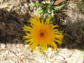
The Showy Copper-Wire Daisy (Podolepis jaceoides) is often found hereabouts in Spring and Summer. Grows to about 80 cm high- very easy to recognise with the split ends of the petals. |
|||||||||||||||||||||||||||||||||
|
|
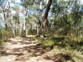
Looking almost due South back up Tabletop Trail at about AMG 956/919, a couple of hundred metres before the sharp bend to the right that marks the turnoff to the long spur between Hole and Zinnia Creeks (ZINNHOLSP7). It’s probably better to continue down via the road, and come up by that spur – as in Section X Photoguide . | |||||||||||||||||||||||||||||||||

