
Contents
|
Cox Comb click on thumbnail to see larger photo. Section P1 +P2 / Z Back |
||||||||||||||||||||||||||||||||||||||||||||||||||||||||||||||||||||||||||||||||||||||||||||
|
Tabletop Trail, and a couple of
options at the end, make this a versatile way into Blue Mountain
Creek and the Macleay. The profile starts from CCOMBSP1, but it is
likely you will visit Zinnia dam first, as it is a long way to the
next water.
and
Section P2 If you are heading downstream to the Macleay/ Blue Mountain Creek junction, take the right NE ridge. Stay on the centre of the ridge as it gradually veers around to the right E to reach Blue Mountain Creek opposite Lorraines Pass at waypoint BMC+TTOP2 56J AG66 0398822.6596075. You are then a couple of km of easy walking from Macleay junction (see photoguide below) Section Z If you are heading up Blue Mountain Creek to Postmans Creek, continue exactly down the True North ridge till you reach waypoint TTOPNRIDG1 56J AG66 0397650.6596350. Then reset & head to BMC+TTOP1 56J AG6 60398100.6596600. You will arrive at Blue Mountain Creek about 200 m below Postmans Creek junction (no photos for this last section). |
||||||||||||||||||||||||||||||||||||||||||||||||||||||||||||||||||||||||||||||||||||||||||||
 |
 |
 |
||||||||||||||||||||||||||||||||||||||||||||||||||||||||||||||||||||||||||||||||||||||||||
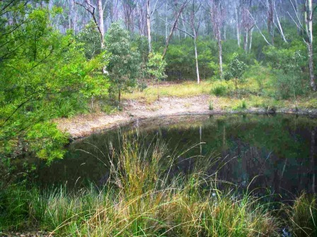
| WATER REMINDER Waypoint ZINNIADAM at AG66 973.921. The water will need tablets or boiling before use. Then it is best to walk about 125 m NNW to meet Tabletop Trail 4WD road at AG66 972.922, and walk along it 500 m, crossing Zinnia Creek, to CCOMBSPN1.(Photo Don Hitchcock) |
Just after the junction of Tabletop Trail 4WD and the ridge track leading up to the Cocks Comb (CCOMBSPN1). Here a broad flat ridge with thicker soil supports a dense stand of wattles under Fuzzy Box. |
There is also some particularly healthy Bulldog ants ( Myrmecia species) along the track. Their bite can be very painful and dangerous if you are allergic to them. Experienced walkers are generally very careful where they sit in Australia! (Photo Martin Lang) |
||||||||||||||||||||||||||||||||||||||||||||||||||||||||||||||||||||||||||||||||||||||||||
 |
 |
 |
||||||||||||||||||||||||||||||||||||||||||||||||||||||||||||||||||||||||||||||||||||||||||
|
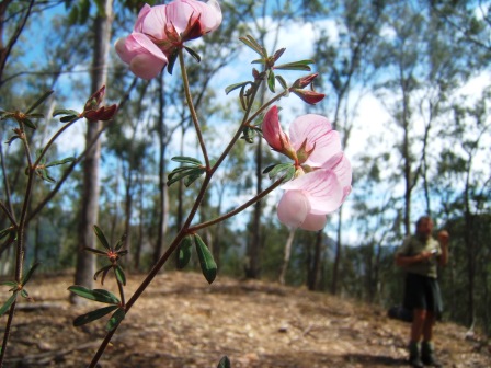
The Australian Lotus (Lotus australis) is often found halfway (as here) down the steep ridges of Oxley Wild Rivers National Park, in dry skeletal soil. |
The final 200 m to the end of Tabletop Trail 4WD road. |
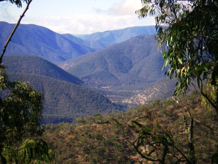
View from the above point on the road, looking NNE with Enmore Long Ridge running across the middle distance, descending to the right between Blue Mountain and Postman Creek. Note the narrow dark green of an unnamed rainforest gully. There are about 190 plant species restricted to such sites in Oxley Wild Rivers National Park. |
||||||||||||||||||||||||||||||||||||||||||||||||||||||||||||||||||||||||||||||||||||||||||
 |
 |
 |
||||||||||||||||||||||||||||||||||||||||||||||||||||||||||||||||||||||||||||||||||||||||||
|
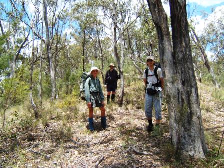
Group shot, at the end of the road. From here, navigation can be a bit tricky, hence full waypoint coordinates TTOPNRIDG3 56J AG66 0397506.6594306. Remember that the above coordinates are to the nearest metre- the bold numbers are what you use to get within a 100 m on the map – you would read them as AG66 975.943(Photo Don Hitchcock) |
View to the NW, up the Macleay above Blue Mountain Creek junction, taken a little below TTOPNRIDG3 . (Photo Don Hitchcock |
The narrow ridge makes navigating easy for a while after the road ends. Still, it’s best to have your GPS to set to head for TTOPNRIDG2 - 56JAG66 0397700.6595400 ASL 640 m (for normal map use, read as AG66 03 977.954). Fuzzy Box with an understorey of Cassinia and Bulloak (Allocasuarina luehmanni). |
||||||||||||||||||||||||||||||||||||||||||||||||||||||||||||||||||||||||||||||||||||||||||
 |
 |
 |
||||||||||||||||||||||||||||||||||||||||||||||||||||||||||||||||||||||||||||||||||||||||||
|
Western Boobialla (Myoporum montanum) is a bright green shrub 2-8 m high with alternate simple leaves 3-14 x 0.3-4 cm, and tubular, deeply 5-lobed white flowers often spotted with purple in the throat, 7-8 mm long. It is near the eastern limit of its range here. It likes dry skeletal soils, inland. (Photo Don Hitchcock) |
St Andrews Cross Spider (Argiope keyserlingi) A female. All these spiders build orb webs. In the middle they put four thickened zigzag strips in the shape of a cross . The spider then hangs head down with its legs pairs together over the cross. There is a brilliant website http://www.brisbaneinsects.com/brisbane_weavers/StAndrew.htm which gives a lot more detail. (Photo Martin Lang). |
This photo was taken from about TTOPNRIDG2, looking across Blue Mountain Creek. Lorraine once suggested we climb the low pass in the centre as a short-cut into the upper Macleay, visible beyond (it cuts off about 3 km). It is very loose, covered with burrs, and quite gripping in parts. Hence the term “Lorraine’s Pass’. Among Armidale bushwalkers it is an an appealing but useless short-cut |
||||||||||||||||||||||||||||||||||||||||||||||||||||||||||||||||||||||||||||||||||||||||||
 Taken from a bit below the steepest part at AG66 983.959. A couple of hundred metres before the ridge narrows and swings around to the right. The light in the top right corner is coming over Lorraines Pass. |
||||||||||||||||||||||||||||||||||||||||||||||||||||||||||||||||||||||||||||||||||||||||||||
 The Tiger Orchid (Cymbidium canaliculatum) is widespread but somewhat uncommon in Oxley Wild Rivers National Park, on the riverbanks or a bit of the way up ridges. |
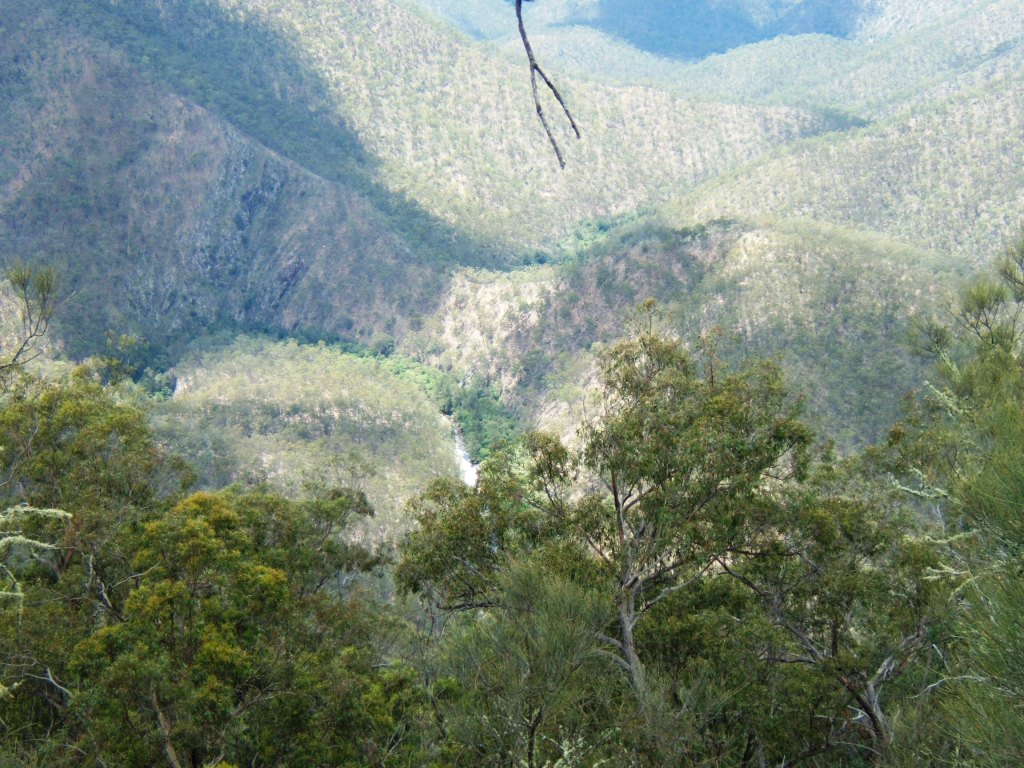
 Looking across Blue Mountain Creek to Postmans Creek in the far distance. It is a sharp drop into the creek from here. No chance of a short cut, but we’re only about 300 m to the water more or less behind us in the photo. (Photo Don Hitchcock). |
 Beautiful Blue Mountain Creek. You’ve come down from about 900 m above sea level at CCOMBSPN1 to 260 m ASL at BMC+TTOP2. I will bet your legs appreciate the rest! (Photo Don Hitchcock) |
||||||||||||||||||||||||||||||||||||||||||||||||||||||||||||||||||||||||||||||||||||||||||

